
Want a road trip that feels bigger than Texas? The drive from San Antonio to Big Bend National Park is a classic Southwest run, long desert miles, small towns, and big horizons that make you pull over “just to look.”
Plan on 3 to 5 days if you want more than a quick photo stop. You’ll have time for scenic drives, a canyon walk, and at least one night under a sky full of stars.
There are two main ways to get there: US 90 is the scenic, border-country route; I-10 is the faster, steadier option. Either way, Big Bend is remote, so planning matters. Top off gas, carry extra water, and download offline maps before you lose service. This guide breaks down route choices, can’t-miss stops, and a simple Big Bend plan that works for first-timers.
Pick your route, US 90 for scenery or I-10 for speed
From San Antonio, expect about 6 to 8 hours of driving one way before stops, and most trips include stops. The “right” route depends on what you want the drive to feel like.
US 90 gives you more variety, water views near Del Rio, and a string of West Texas towns. On the other hand, I-10 is smoother and often faster, with long stretches that can eat miles quickly.
A smart play is one route out and the other back. You’ll avoid repeat scenery and can time stops around daylight. Also, keep a few realities in mind: cell service gets spotty, especially as you near the park, and border patrol checkpoints can happen on US 90. Carry ID and add a little buffer time.
If you want a quick overview of the two main approaches from San Antonio, the local rundown on driving from San Antonio to Big Bend matches what most repeat visitors recommend.
The US 90 route: lakes, border-country views, and classic West Texas towns
US 90 heads west through Uvalde and Del Rio, then continues across wide-open border country. It can feel slower because you’ll pass through more towns, hit more stoplights, and probably stop more often.
Near Del Rio, Amistad National Recreation Area is a solid leg-stretch. Even 30 to 60 minutes helps, and the water views are a nice change from desert brush. After that, the road settles into long, quiet sections where you’ll want a full tank and a downloaded map.
Many travelers like Marathon as a calm “last stop” before the park. It’s close enough to make the final push easy, and it keeps you from rolling into Big Bend late and tired. One more practical note: along this route, checkpoint delays happen sometimes. They’re usually brief, but they’re part of the rhythm out here.
The I-10 route: the quickest way to reach Big Bend, plus an optional national park detour
I-10 runs west toward Fort Stockton, then you’ll drop south on US 385 toward Marathon and the park. The pace is simpler, with fewer slowdowns, and you’ll often see higher speed limits on open stretches (still, watch changes near towns).
If you’re trying to squeeze Big Bend into a shorter window, this route helps. It also pairs well with an optional “second park” idea: detour north to Guadalupe Mountains National Park if you want a true national park hike on the same trip. It adds time, but it’s a memorable contrast to Big Bend’s river canyons and desert basins.
Best stops between San Antonio and Big Bend (so the drive feels like part of the vacation)
The key is picking a few stops that change the mood. Too many quick stops can make the day feel endless. Aim for one water break, one history or culture stop, and one night-sky moment.
If you break up the drive, Alpine and Marathon make it easy to enter the park rested. If you want to be close to the west side, Terlingua works well for a pre-park night. Wherever you sleep, do the unglamorous tasks before you enter the park: fuel up, grab groceries, and refill water. Options get limited fast once you’re inside.
For ideas beyond the highlights below, this San Antonio to Big Bend road trip itinerary is helpful for seeing what else fits your style.
Quick, worthwhile stops: Amistad, Fort Davis, McDonald Observatory, and Terlingua
Amistad National Recreation Area works as a short reset. Plan 30 to 60 minutes for overlooks and a stretch.
Next, consider pairing Fort Davis National Historic Site with McDonald Observatory. Give yourself 1 to 2 hours for the history stop, then save the observatory for evening if you can. In March, nights often cool down, and West Texas skies can feel unreal.
Finally, Terlingua Ghost Town is a fun pre-park stop near the west entrance area. It’s good for photos, a meal, and that first taste of desert character before you hit the park roads.
Quick rule: if you’re arriving after dark, stop early and sleep. Big Bend roads are paved in many areas, but wildlife and fatigue don’t mix well.
Where to base yourself near the park: inside Big Bend or just outside the gates
Staying inside Big Bend saves driving time each morning. That matters because distances are bigger than they look on a map. Less windshield time means more time on trails and overlooks.
Staying outside the park (think Terlingua area) often gives you more food choices and a looser schedule. The tradeoff is extra driving, especially if you plan to bounce between the west side, Chisos Basin, and the east side in one trip. Pick a base that matches your “home base” style, either convenience or variety.
Big Bend National Park made simple: a first-timer plan for 2 to 3 days
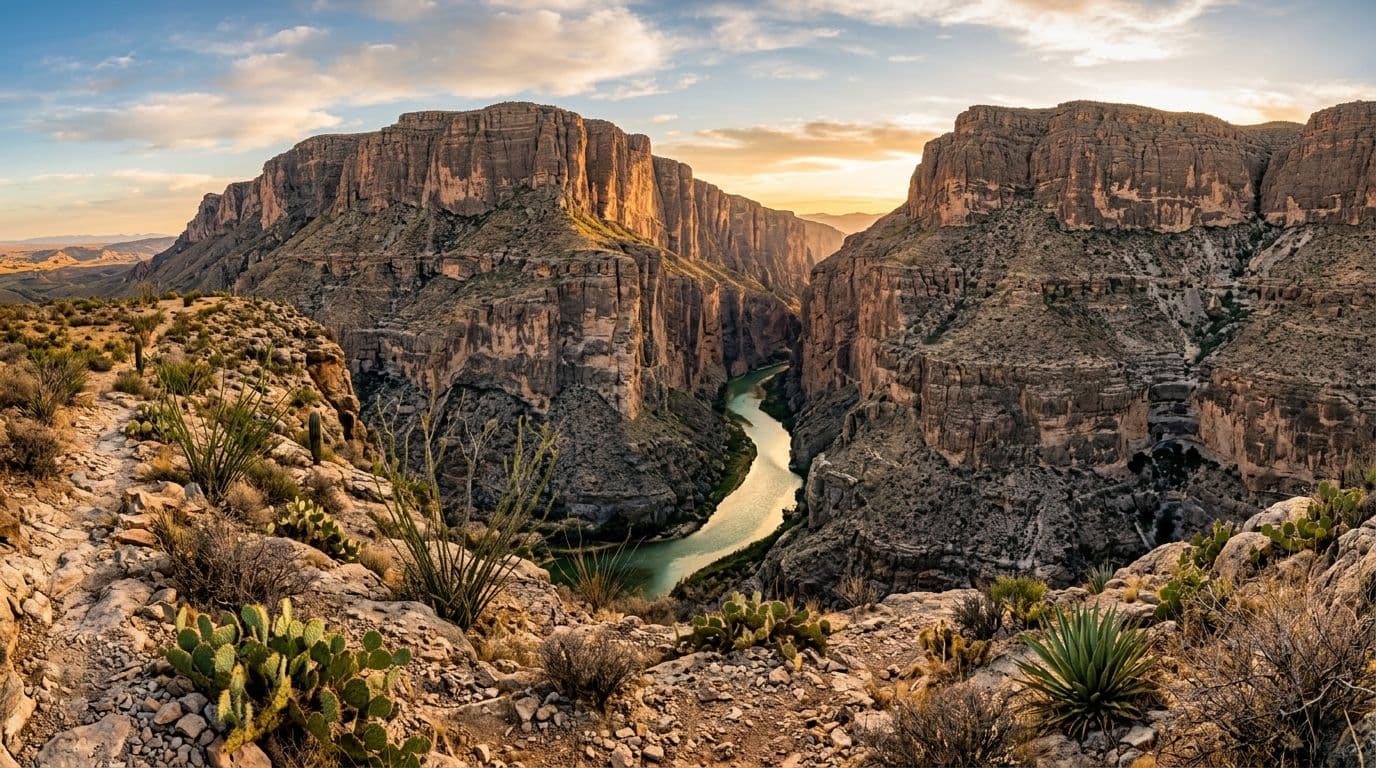
Santa Elena Canyon glowing in late light, created with AI.
Big Bend gets easier when you think in three areas: west, central, and east. That simple mental map cuts down on backtracking.
The west side is where you’ll find Ross Maxwell Scenic Drive and Santa Elena Canyon, two of the park’s most famous highlights. The central area includes Chisos Basin, higher elevation, cooler air, and big views. The east side points you toward Rio Grande Village, open desert edges, and quieter sunsets.
Safety basics are simple but important. Carry plenty of water, start hikes early, and take sun seriously. March can feel perfect in the morning, then turn hot and windy by afternoon. Nights can also get cool, especially higher up.
If you plan to drive dirt roads, ask rangers about current conditions. Some backcountry routes change after rain, and closures can linger after flood damage. As of late February 2026, reports note Black Gap Road is closed and Hot Springs Road is closed, while many main paved roads remain open. Check again when you arrive because conditions can change quickly.
For a broader overview of highlights and timing, this Big Bend National Park travel guide is a solid companion read.
Day-by-day idea: one scenic drive day, one mountain day, and one river day
Think of this as a flexible flow, not a strict schedule.
Day 1 can focus on the west side. Drive Ross Maxwell Scenic Drive at a relaxed pace, then walk into Santa Elena Canyon if conditions allow. Light changes fast here, so plan extra time for overlooks.
Day 2 fits well in Chisos Basin, where temperatures are often cooler. It’s a good day for a longer hike or a slower wander with big views. If you’re visiting in late spring 2026, keep in mind major construction is slated to start May 1, 2026 in the Chisos Basin area and may disrupt access for a long stretch.
Day 3 can shift to the Rio Grande Village area for easy sunset walks and wide desert views. Some travelers look for the hot springs, but access and road status can change, so confirm locally before you commit.
Park fees, fuel, and road realities (the stuff that can make or break your trip)
As of March 2026, Big Bend’s entrance fee is $30 per private vehicle for 7 days (motorcycles and per-person options are slightly different). The park is cashless, so bring a card. If you’re adding another park, consider whether an annual pass makes sense for your year.
Fuel planning matters more than most people expect. Fill up in Alpine or Marathon before entering, pack extra water and snacks, and download offline maps. Main park roads are paved and usually fine. In contrast, dirt roads can turn rough after storms and may need high-clearance or 4WD.
Conclusion
A San Antonio to Big Bend road trip works best when you keep the big choices simple. Pick US 90 for scenery or I-10 for speed, choose one or two stops that you’ll actually enjoy, then explore Big Bend by region so you don’t spend the whole trip driving.
Plan early because Big Bend rewards preparation, especially for gas, water, and spotty service. Check conditions right before you leave, and stay flexible once you arrive. Above all, leave room for the slow moments, a canyon in late light, a quiet two-lane road, and a sky full of stars.